
Painswick Beacon Circular Walk and Viewpoint
Painswick Beacon is the site of an ancient Iron Age hill fort in Gloucestershire. Due to it’s height at 283m (928ft), it has arguably some of the best 360 degree views you will find in the Cotswolds.
On a nice clear day you can see the Malvern Hills in one direction and the Forest of Dean and Brecon Beacons in the other. Here is a walking route map which takes you up to the Painswick Beacon. Download the Gloucestershire Walks app to see your position on the map as you walk.


To download the app search ‘Gloucestershire Walks’ on your app store.
© OpenStreetMap contributors
Contains OS data © Crown copyright and database right 2021
Painswick Beacon Walk
2.25 miles
Start point - grid reference 51.815089,-2.175014
This is a short walk with some inclines, taking you from a small car park in the woods up to the Painswick Beacon. Please note that this walks takes you alongside and past the golf course. The route starts by taking you through a small section of woodland until you reach the Painswick golf course. If you are walking clockwise you will travel along a section of The Cotswold Way (beside the golf course) until you reach the steps leading up to the top of Painswick Beacon. At this point you can really appreciate the scenic, panoramic views across the Gloucestershire countryside. Although there is a climb to the top of Painswick Beacon, because you start the walk high up already, it’s not as challenging as some walks to get wonderful views. That said, there are still some steep and uneven sections to deal with. There is also a short detour to the Royal William pub on this walk if you want a bite to eat or drink after your exertions.
Refreshments: The Royal William, Cranham
Painswick Beacon and Popes Wood Walk
When we did the Painswick Beacon walk, we decided to also explore Popes Wood. Although this extended route isn’t currently on the app, we have mapped the walk and plan to add it to the next app update. Rather than return to the start via walking along the edge of the golf course, we dropped down into Popes Wood along a narrow woodland path until we reached a wider track through the woods. It was a lovely addition to the walk and the trek through the woods was a wonderful contrast to the wide open hill. You will require a bit more energy for this walk because you descend further down into Popes Wood before climbing back up to the start through the woods.
To get the Painswick Beacon walk on your phone, just search ‘Gloucestershire Walks’ on your app store.
Here are a few pictures of Painswick Beacon and Popes Wood.
After leaving the small car park (grid reference 51.815089,-2.175014) you stroll through the woods until you reach the edge of Painswick golf course.
A small section of this walk travels along The Cotswold Way which is a 102 mile long footpath running from Chipping Campden to Bath.
This is one of the paths that lead up to Painswick Beacon. It’s not too steep but a bit of effort is still required.
Once you reach the steps it’s just a short final climb to the ridge path that leads to the Painswick Beacon itself.
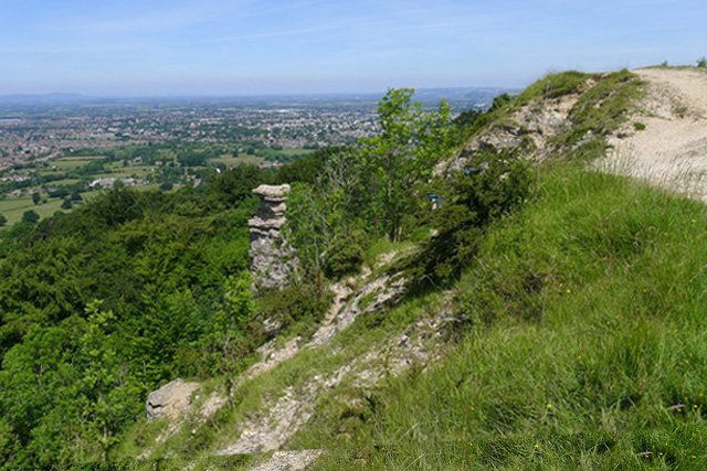
Once you are on the ridge, the views from Painswick Beacon are spectacular. You can see for miles around in all directions. It’s worth taking a bit of time to just sit, relax and fully appreciate the wonderful scenery.
Popes Wood is beside Painswick Beacon and a nice route extension if you want a slightly longer and more energetic walk. It’s not a lot further but does involve a steady climb back up to the original path.
Here are a few more walks with great views near Painswick Beacon.
Leckhampton Hill Walk
8.7 miles from Painswick Beacon

Barrow Wake Walk
5.8 miles from Painswick Beacon