Dovedale Walk and Map
Dovedale is a scenic valley in the Peak District and a very popular beauty spot. Dovedale valley follows the River Dove near the Staffordshire and Derbyshire border and is actually around 3 miles long. We have six Dovedale walks on the Staffordshire Walks app, download the app to view all walks and see your position on the map as you walk.
150+ walks in Staffordshire. Download the app to see your position on the map as you walk. These walks are also available on the Derbyshire Walks app here.
Photo © Mat Fascione (cc-by-sa/2.0)
Dovedale
Dovedale walk 1
0.75 miles
This first Dovedale walk is a simple stroll up and down either side of the wonderful River Dove, with a little stepping stone bridge to enjoy half way around. This option is for those of you that don't have too much time but still want to enjoy the wonderful scenery that this site offers. Heading from the car park, the left side of the river is flat hard surface and suitable for wheels, but the other side on the way back is too bumpy, so if you have a wheelchair or buggy, take the path on the left side of the river there and back instead.
Dovedale walk 2
1.25 miles
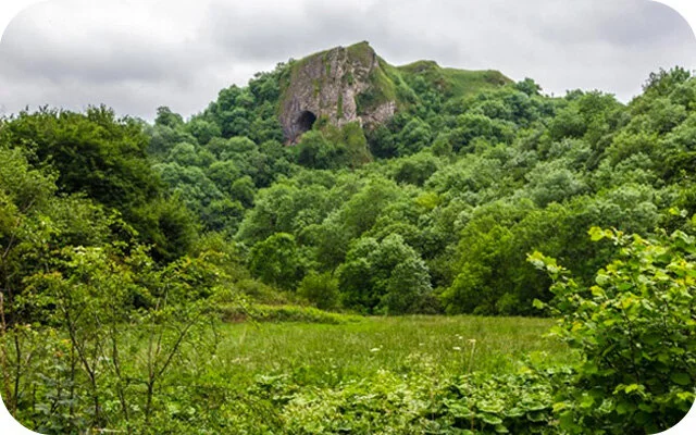
In stark contrast to the first casual route option, this second short Dovedale walk is for the adventurous amongst you! It is basically a very steep climb up to the ridge of the Thorpe Cloud, which actually requires a bit of scrambling at the top, and it rewards you with some breathtaking panoramic views of the entire area. Please be very careful on all aspects of this route as there are dangerous drops, and make sure you have the appropriate clothing and good weather conditions when you go up.
Dovedale walk 3
3 miles
This third beautiful walk is an alternative to the main and popular Dovedale routes, but it's still a wonderful adventure in this lovely area. If you head clockwise, the walk heads along the main River Dove initially, where you can enjoy the river and then cross the picturesque stepping stones. Then, instead of heading deeeper into the Dove Dale, it continues around the base of the majestic Thorpe Cloud hill and then through countryside onto the village of Thorpe. The walk consists of woodland, open fields and the scenic River Dove. There is a little section of road walking on a quiet lane, some mild hills to climb at times, and the option of refreshments at the cafe near the start.
Dovedale walk 4
4.25 miles
This fourth route option is a beautiful but very strenuous and adventurous walk that heads a lot deeper into the Dovedale valley. If you head clockwise, you'll first enjoy a long walk through lovely countryside and around the base of Bunster Hill. There is an optional shortcut marked on the map where you can scramble over the top of this hill, but this isn't for the faint hearted! You don't get off scott free though as eventually, you'll start climbing a very steep hill anyway and then after a while you'll cut into the woods and descend a very steep woodland path until you reach the iconic Ilam's Rock and then head back to the start along the picturesque River Dove Path.
Dovedale walk 5
6.25 miles
This fifth option is basically the glory walk of Dovedale valley and takes you all the way along the river and through the majestic valley until you reach the little village of Milldale. After a little explore of the village, you'll then head back on the other side of the river, joining up with the path you used on the way there after a while. There will be plenty of photo opportunities as you walk within this beautiful scenery and you'll visit the Dove Holes, the intriguing Ilam Rock, Lovers Leap and the iconic stepping stones as you go.
Dovedale walk 6
7.25 miles
This Dovedale walk is the equivalent of going off-piste on your favourite ski resort! If you head clockwise, the first half of the walk takes you along the beautiful, but well-trodden River Dove path through the valley as in the fifth route. However, once you've reached the village of Milldale, the return leg of the walk then heads off the main track into the majestic open access hills to the east of Dove Dale. You'll enjoy wonderful views all along this route, but please be careful on the hills and make sure you go prepared with the appropriate clothing and refreshments.
Dovedale Walk Route Map (route 5)
Download the Staffordshire Walks app to see your position on the map as you walk.
© OpenStreetMap contributors
Contains OS data © Crown copyright and database right 2021
Here are a few comments from people who have walked the Dovedale walks on the app.
Dovedale walk 4
A great walk! Gradual climb up to the ridge. We cut the corner off the first hill to follow a well trodden sheep track rather than go right round on the wider flatter path. It was fun but rocky under foot....On the descent we stuck to the trail which is marked alternate route, a nice but tricky descent. We were glad we didnt take the even harder shortcut straight down....The stepping stones plus some of the path were covered in water, but a fun adventure with shoes and socks off!! ...A stunning walk all round! Not for those who don’t like uneven ground.
Dovedale walk 4
We started clockwise from the car park and took the short cut up the hill. Very rocky ground for some parts.
Dovedale walk 5
Such a lovely, picturesque walk. Highly recommend. A bit of an incline up the steps about 10 minutes into the walk but other than that relitively flat walk. The village of Milldale very quaint with a little shop serving sandwiches, pasties and ice creams. Public toilets at the start of the walk by the car park (20p) and in Milldale also (free). There was also a water tap in Milldale to fill up any bottles you may have.
Dovedale walk 5
Toilets at start and end. Pretty flat for most of walk but pretty steep hill/steps in middle.
Dovedale walk 3
Great walk, we took 5 year old twins, was perfect distance but extremely muddy as we had lots of rain the day/night before. Need wellies if wet.
Dovedale walk 1
Beautiful location, but crowded on a bank holiday weekend.


